Home › Route & Stations
Route and Proposed Stations
Last updated: 2 July 2026 · Route announced 5 May 2025
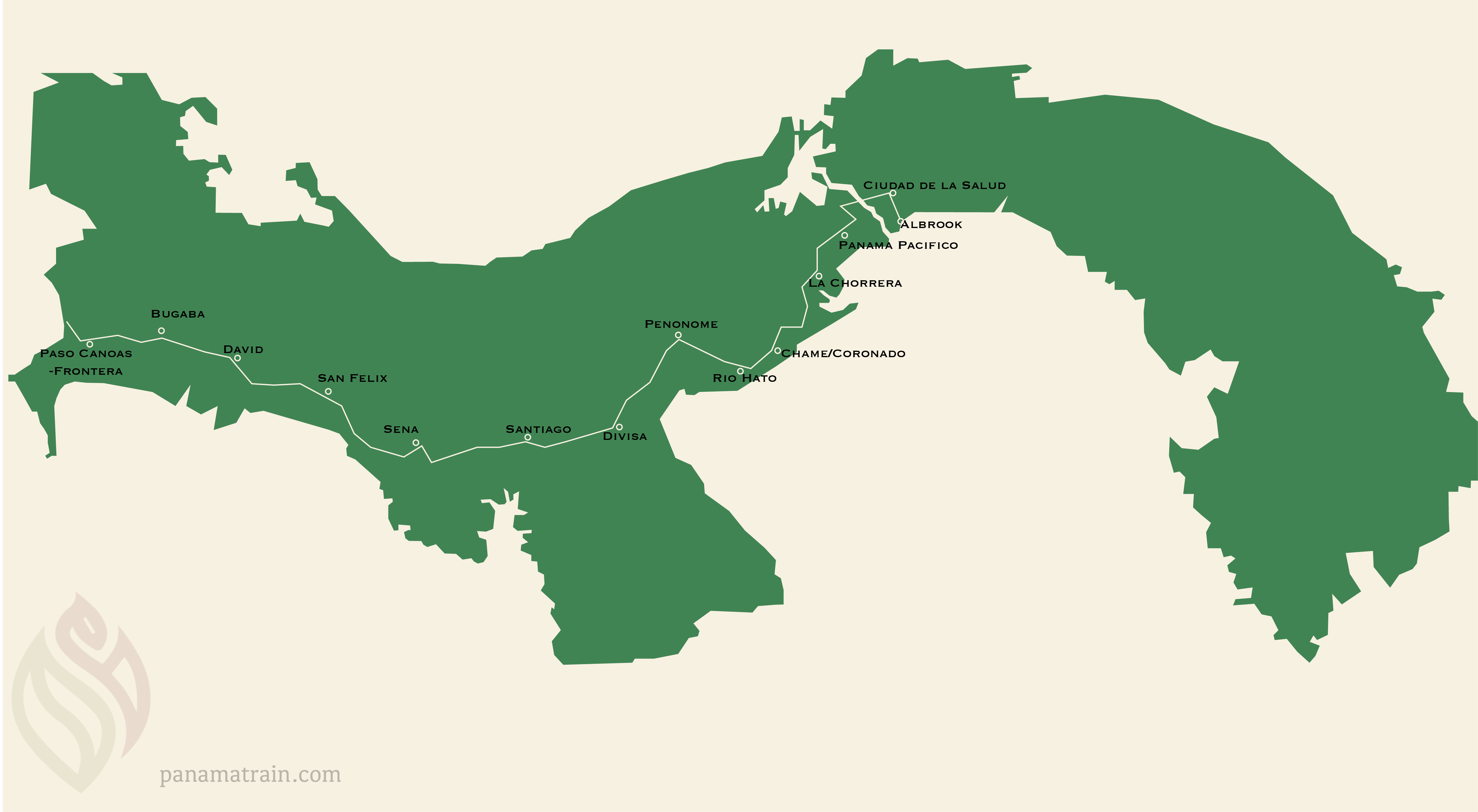
The proposed line runs about 475 km from Panamá Pacífico to Paso Canoas on the Costa Rica border, with 14 stations across 5 provinces (Panamá, Coclé, Herrera, Veraguas, Chiriquí). Phase 1 covers Panamá City to Divisa. Design targets: passenger service up to 180 km/h, freight up to 100 km/h, and a Panamá City–David trip of about 3 hours.
The corridor at a glance
- ~475 km total, Panamá Pacífico → Paso Canoas
- 14 stations across 5 provinces
- ~3 hours Panamá City to David (vs. 6–7 hours by car)
- Up to 180 km/h passenger express; 100 km/h freight
- Built in two phases: Phase 1 Panamá–Divisa, Phase 2 Divisa–Paso Canoas
Stations, north to border
| Station | Province | District | Phase | Note |
|---|---|---|---|---|
| Ciudad de la Salud | Panamá Oeste | Arraiján | Phase 1 | Beside the new Ciudad Hospitalaria |
| Albrook | Panamá | Panamá City | Phase 1 | Capital terminus; Metro Line 1 + national bus terminal |
| Panamá Pacífico | Panamá Oeste | Arraiján | Phase 1 | Links to Metro Line 3; special economic area |
| La Chorrera | Panamá Oeste | La Chorrera | Phase 1 | Largest city west of the canal (~200,000) |
| Chame / Coronado | Panamá Oeste | Chame | Phase 1 | Pacific beach corridor; tourism demand |
| Río Hato | Coclé | Antón | Phase 1 | Beside Scarlett Martínez International Airport |
| Penonomé | Coclé | Penonomé | Phase 1 | Provincial capital; central-provinces market |
| Divisa | Herrera | near Parita | Phase 1 terminus | Crossroads to the Azuero peninsula |
| Santiago | Veraguas | Santiago | Phase 2 | Halfway hub between capital and David (~95,000) |
| Soná | Veraguas | Soná | Phase 2 | Agricultural district; cattle market |
| San Félix | Chiriquí | San Félix | Phase 2 | Gateway to the Ngäbe-Buglé comarca |
| David | Chiriquí | David | Phase 2 | Third-largest city; commercial heart of the west (~150,000) |
| Bugaba | Chiriquí | La Concepción | Phase 2 | Coffee, vegetables, dairy |
| Paso Canoas | Chiriquí | Barú | Phase 2 terminus | Border crossing with Costa Rica |
Station names and the alignment come from the official announcement of 5 May 2025 and may change as feasibility studies conclude. Population figures are public-source estimates.
Phasing
Phase 1 (Panamá City–Divisa) is where studies, the environmental review, and property surveys are concentrated. Phase 2 (Divisa–Paso Canoas) extends the line west through Veraguas and Chiriquí to the Costa Rican border.